EFLIGHT 2003 X - Eclipse Flight Planning & Navigation S/W
 Updated: 04 Apr 2003 for MacOSX
Glenn Schneider
Steward Observatory
933 N. Cherry Avenue
University of Arizona
Tucson, Arizona 85750
gschneider@as.arizona.edu or gschneider@mac.com
EFLIGHT 2003 X - Eclipse Flight Planning & Navigation S/W Updated: 04 Apr 2003 for MacOSX
Glenn Schneider
Steward Observatory
933 N. Cherry Avenue
University of Arizona
Tucson, Arizona 85750
gschneider@as.arizona.edu or gschneider@mac.com
Prelude on the Art of Eclipse Chasing
The "art" of eclipse chasing sometimes poses difficultand complex logistical, technical (and financial) problems. Unlessyou are one of the very fortunate < 1% of the world's population which,by pure luck, has a Total Solar Eclipse fall in your backyard sometimeduring your life, then getting to the path of totality often becomes achallenge, if not an obsession. I suppose I am one of the obsessed. At the risk of redundancy, but for necessary background, elsewhere I hadpreviously written: "Glenn Schneider is an UMBRAPHILE. Literally a "shadowlover", but properly applied, one who is addicted to the glory and majestyof total solar eclipses. Those who have basked in the moon's shadow willknow what I mean without further explanation. Those who have not may havedifficulty in understanding that umbraphillia is not only an addiction,but an affliction, and a way of life. The real raison d' etre for manyof us. The more common and prolific term "solar eclipse chaser" is nearlysynonymous, but somehow does not convey the depth of commitment to thislifelong endeavor. Once every 16 months, or so, (on average) umbraphileswill drop whatever they are doing and trek by plane, ship, train, foot,and camel-back to gather along a narrow strip in some remote God- forsakencorner of the globe defined by the inexorable laws of celestial mechanics.Newtonian physics heeds no national boundaries, and neither do umbraphiles.Wherever the solar photosphere will be extincted, enshrouded by the ashenlunar disk, umbraphiles will revel in the quasi-twilight darkness."
Why EFLIGHT?
Occasionally, the path of totality (i.e., the region onor above Earth's surface where a total eclipse may be viewed) isso elusive that an airborne observation of such an eclipse is by far thepreferable, if not the only, viable alternative. Such was the caseon 03October 1986, and again on 30June 1992. And, the very fortuitous geometrical circumstancesassociated with the 21June 2001 total solar eclipse could have given rise to an hourlong totality if fate had not tragicallyintervened. Hitting a moving target (the moon's shadow) from amoving platform (a high speed aircraft) is intrinsically not too complexa problem, though it certainly is non-trivial. To do this successfully,while optimizing a flight intercept to strike a desired balance betweenduration, observability (i.e., line-of-site restrictions due to aircraftwindows), and cost, must be approached with both care and rigor. The circumstances of the 03 October 1986 eclipse were so constrained (seethe above linked page), that virtually no deviation from a very laboriouslypre-constructed flight intercept could be tolerated. By 1992, however,the availability and capabilities of portable (aka "laptop") computershad so rapidly evolved, that eclipse flight re-planning in reactionto situ conditions became possible. As a result, EFLIGHT92- an integrated eclipse flight planning and navigation S/W package- was engineered for the then fledgling Macintosh PowerBook 100 serieslaptop computers, and then successfully used to navigate a DC-10 throughthe path of the 30 June 1992 eclipse. (As it begs the question... No. I did not have to "turn off and put away" my Powerbook 170 during take-offfor that flight, though I suppose it helped that I was occupying the navigator'sseat in the cockpit).
The 23 November 2003 total Solar Eclipse
With the advent of the 23November 2003 total solar eclipse, a prime candidate for an airborneeclipse observation, I have dusted off EFLIGHT after the tragicaccident on 25 July 2000 canceling its planned use, in its 2001incarnation, on the Concorde for the 21 June 2001 eclipse. Given the large degree of "inaccessibility" to nearly all of the 23 November2003 eclipse path, such a flight was crying to be flown. This eclipse hasmet with considerable interest, likely due to the added enticement of itsremoteness, and planning for such a flight has actually been underway forsome time. Two Antarctic over-flights have evolved which have (andcontinue) to use EFLIGHT to develop their flight concepts, requirements,specifications, and plans:
1) CroydonTravel/QANTAS: Using a Boeing 747-400 from Perth, Australia.
2) TravelQuest(Sky & Telescope)/LanChile: Using an Airbus A340 from Punta Arenas,Chile.
The baseline Eclipse Flight Centerline Intercepts andTotality Runs for these flights are illustrated and summarized HERE.
EFLIGHT 2003 X (and UMBRAPHILE) and their predecessors
On the "technical" side, many have queried me about EFLIGHT(which I have recently ported to run under MacOS X and is now a nativeJaguar/Aqua* application). So, here I provide an overview of whatit is, and what it can (and will) do. But first...
HISTORY: The core algorithms for EFLIGHThave a long history. The computations of the astronomical ephemeridesand eclipse circumstances performed by EFLIGHT were originally implementedin 1974 in APL on a Xerox Sigma 9 computer under the UTS (and later theCP-V) operating system. These core algorithms have been used for planningground-based and/or airborne observations for every total solar eclipsesince. Early in its history, the software was migrated to other mainframecomputers and operating systems (including the IBM/360, Ahmdahl/470VM andHarris 500). By 1979 the software had also been implementedin a combination of BASIC and 6502 assembly code and "packaged" for useon an APPLE II computer. The eclipse predication and planning softwarewas integrated into a end user oriented system called CENTERLINEand migrated to the microAPL desktop environment (in the Waterloo languagesystem) on the Commodore SuperPet SP9000 in 1982. By 1985 CENTERLINEhad again moved, to a VAX/VMS environment, implemented in APL11 under RSX.CENTERLINE was then augmented with some rather special purpose algorithmsto aid in the planning of the airborne eclipse observation of the October,1986 eclipse in the north Atlantic near Iceland. By 1988, CENTERLINEwas transformed to the paradigm of the graphical user interface under (Mac)OS 6, implemented first on a Macintosh SE in APL/68000. Contemporaneously,following the 1988 eclipse, a real-time automated camera controller calledROSE(the Reprogrammable Observer for Solar Eclipses) was developed for theRockwell AIM-65 (6502) environment as a machine/assembly language program,which relied on computationally derived inputs from CENTERLINE.ROSE,supported computationally by CENTERLINE, was used successfully duringthe exceptionally long total solar eclipse of 1991. With the MacintoshPowerbook, in 1992, ROSE and CENTERLINE were symbioticallymerged into a single APL/68000 application running under (Mac) OS 7, thefirst prototype of UMBRAPHILE. But UMBRAPHILE would not be field-tested (quite successfully) untilthe total solar eclipse of 1995 in Ghanoli, India.
Contemporaneous with the early development of UMBRAPHILE,a separate (Mac) OS APL/68000 application, EFLIGHT predicated onthe same core algorithms, was born to plan and assist in the real-timenavigation of a VASP airlines DC-10 to observed the total solar eclipseof June 1992 over the South Atlantic. UMBRAPHILE evolved inthe late 1990's to a user friendly MacOS application was subsequently usedemployed for the 1997 (Siberian) 1999 (Black Sea), total solar eclipses.EFLIGHTwas upgraded and modified for MacOS 9 nativity as an APL Level II for PowerMacintosh application in 2000, in preparation for a planned nearly one-hourairborne observation of the June 2001 eclipse with an Air France Concorde. The horrific accident outside of Paris on 25 June 2000, which lead to thesubsequent grounding of the Concorde fleet, resulted in the upgradedEFLIGHTbeing put "on the shelf". Observing instead from the ground the June2001 eclipse, in Zambia, was photographed with UMBRAPHILE, for the firsttime, by multiple eclipse photographers and at different locations alongthe path of totality (e.g., see results from D. McGlaun). And,UMBRAPHILEwas used again for the 4 December 2002 eclipse, with an three MacintoshPowerbooks spanning 10 years of technology (68K Series 100 by J. Friedland,to G4 by J. Moskowitz and myself) within 5 meters of each other in themiddle of the Australian outback.
In preparation for the 23 November 2003 eclipse, whichwill be viewed by two aircraft over Antarctica, EFLIGHT underwentadditional modifications and a port to run natively under MacOS X. Thecurrent version of EFLIGHT (2003 X version 2.0.0), described here,is written in APLX for Macintosh (version 1.1.5) from mciroAPL Ltd. (UK).Though designed for MacOS X it will run in "Classic" mode under MacOS X,and a release can be prepared to run "native" under MacOS 9.
.
An Umbraphillic Derivative
EFLIGHT is an eclipse circumstance calculator -but one specifically designed to address the problem of interceptingthe moon's shadow from a moving aircraft. The core algorithms forthe computation of at-altitude local and centerline eclipse circumstancesare the same as those employed in UMBRAPHILE. What? You aren't familiar with UMBRAPHILE? Then please read about that freeware application to fill in the necessarybackground details, which I won't repeat here. EFLIGHT actuallyco-evolved with UMBRAPHILE, so much so that it uses the same inputdata file structure, and both shares many common "user" interface elements. However, UMBRAPHILE was designed as a more generic application forunrestricted distribution (and hence, "user proofed"). EFLIGHTsometimes requires a bit more hand-holding, so you won't find a down-loadableapplication here. For those seriously interested please contactme, but I suggest a likely necessary sentient accessory to havewith it on your airplane if you plan to use it there. At least, somethink I am sentient, so I will be using it in situ on 23 November 2003from the flight deck of the Croydon/QANTAS (Boeing 747-400) eclipse flightover the Antarctic.
Starting up and Running EFLIGHT 2003 X
To start up EFLIGHT just double-click theEFLIGHTICON:
EFLIGHT will then :
1) Bring up an introductory message in a dissmissabledialog (Figure 1), indicating the software version release number. Ephemeris data is pre-loaded with the application for a specific totalsolar eclipse, though ephemeris data my be imported (as described later)for other eclipses. The eclipse for which eclipse ephemeris data is providedby default as part of the application is also noted at startup in the Introductorydialog.
Figure 1. EFLIGHT Introductory Dialog.
2) Pop up "Info Window" (Figure 2) providing informationon how to contact me and where to obtain the latest information about EFLIGHT.By design, this window cannot be closed or minimized while running EFLIGHT,but it can be moved "out of the way", or behind other windows.
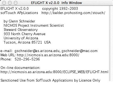
Figure 2. EFLIGHT Info Window
3) Create a text "Output Window" (Figure 3), which EFLIGHTwill use for displaying textual information and data generated by EFLIGHT. The text output window will initially display basic information germaneto the operation of the current EFLIGHT release:
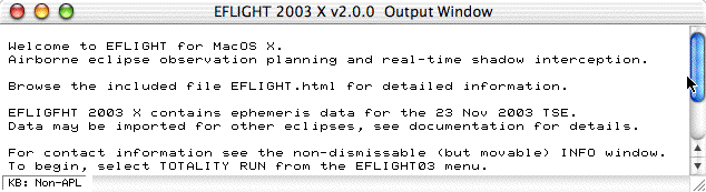
Figure 3. EFLIGHT Output Window
The introductory notes (which may be release dependent)will be cleared when EFLIGHT subsequently produces a text displayin the output window, but these messages may be refreshed by selectingHELPfrom the EFLIGHT menu.
The text output window is scrollable, as the tabular outputproduced by EFLIGHT can be quite lengthy (depending upon the inputparameters supplied by the user). The output window, initially, may besmaller than the width of the TABULATE TOTALITY RUN table (describe later), but it may be maximized to the full screen sizeor resized, as usual, by clicking and dragging the lower right edge ofthe window.
The title bar of the text output window will change nameto reflect the current window content, and to display computational statusmessages for computationally intensive operations in progress.
EFLIGHT 2003 X Menus
The following menus and associated menu items will appearto the right of the Apple menu after starting up EFLIGHT:
The EFLIGHT Menu
The items under the EFLIGHT menu perform the computationaland display tasks for planning, optimizing, and executing an eclipse flighttotality run. Those items, are described in detail below. Theother menus provide standard system services, and so, are not discussedhere.
1) COMPUTE TOTALITY RUN
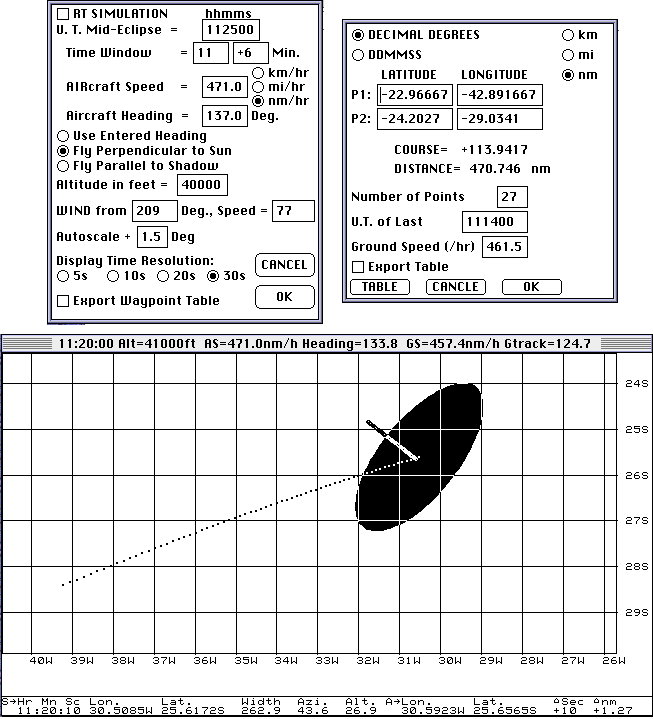
An EFLIGHT "totality run" is fundamentallyparametrized by specifying a Universal Time (U.T.) at which the aircraftis to be co-axially located in the umbral shadow* (i.e., the instant ofmid-eclipse). This is combined with the flight altitude, aircraftspeed, and several other parameters to develop a set of time-ordered andtime-dependent way points (latitude and longitude tuples) which can, forexample, be loaded into an aircraft's navigation/autopilot and/or FMS/FMCsystems. Importantly, EFLIGHT can re-compute a "corrected"flight plan in situ given changing wind conditions enroute to theeclipse intercept. The set of parameters and selectable options which controlthe computation, and later tabulation and display of the the totalityrun, is entered through the EFLIGHT "flight definition dialog" (Figure4) which is presented when the COMPUTE TOTALITY RUNitem is selected from the EFLIGHT menu.
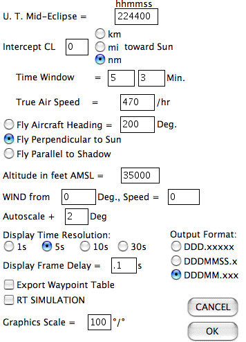
Figure 4. A centerline-intercept flight profile is created in compliance
with a set parameters specified through the EFLIGHT flight definitiondialog.
U.T. Mid-Eclipse:
Specifies the Universal Time (with one second granularity)at which the aircraft is to be concentrically located in the moon's shadow.
Time Window:
Specifies how many minutes before and after mid-eclipsethe aircraft is to fly on the to-be-computed "totality run".
INTERCEPT CL:
For some eclipses a non-central intercept through theumbra might be desirable, and such an offset can be specified through theINTERCEPT CL option. This option has been disabled for the23 November 2003 total solar eclipse.
(True) AIRcraft Speed:
This is the true AIR speed (not the GROUND speed, whichEFLIGHTwill compute based upon windage and course). The true AIRcraft speedmay be entered in kilometers/hour, (statute) miles/hour or nautical miles/hour.
(True) Aircraft Heading:
True Heading (not magnetic*) may be entered (indegrees) - but is used only if "Use Entered Heading" is selected.
Choice of Flight Vectors:
As defined in (3) a, b, and c, above. Flying perpendicularto the Sun will present an optimized view of the eclipse out the aircraftcabin windows, and will typically be necessary anywhere along the pathexcept relatively near the points of local noon or midnight. Flyingparallel to the shadow will maximize the duration of totality - but wouldlikely not be practical near the beginning or end of the path (as the aircraftwould then fly "across the shadow" and the sun would not be visible throughthe cabin windows, or would be a real neck-craner).
Altitude in feet:
Fixed altitude of the aircraft above MSL.
Wind Speed/Direction:
Specify direction wind is FROM in degrees, and the WindSpeed. Note: Wind Speed is taken to be in same units selected forAIRcraft speed.
Autoscale:
The EFLIGHT graphical output (discussed below)is scaled to exactly fit the most constrained end-points along the pathof totality at the boundaries of the graphics window. In settingup the output display an optional "buffer" to move the endpoints from thecloser end of the window (in degrees of latitude, or longitude) may beentered.
Time Resolution:
Specifies the temporal granularity (in seconds) for thecomputation of eclipse circumstance and navigation data. (see Tabulateand presented graphically, but also affects the precisionof the times of contacts as seen from the moving aircraft. For computationspeed, use coarse time intervals, for initial flight planning and evaluation. For high precision contact times and circumstances use 1s granularity.
Export Way point Table:
Check this box to automatically also write the informationpresented in the output window to an ASCII file.
RT SIMULATION:
Check this box display a Real Time (i.e., system clocktime synchronous) graphical simulation when the DISPLAY TOTALITY RUNitem is subsequently selected from the EFLIGHT03 menu. .
OUTPUT FORMAT:
Three output formats are available for aircraft and umbralshadow coordinates (latitude and longitude) as displayed in the text window(but not in the graphics window) and/or exporting the content of the textoutput window to an ASCII file. Select from: decimal degrees; degrees,minutes, seconds (and fractional seconds to the nearest 0.1"); or degreesand minutes (and fractional minutes to the nearest 0.001').
* EFLIGHT uses true, not magnetic headings. For most locationson the Earth the difference can be computed by a magnetic field model suchas the NGDC/NOAAmodel. Near the magnetic poles both the magnetic declination and gradientof the declination can be very large. The South magnetic pole is at 66°Slatitude, 139°E longitude. For the intercept location given inthe Figure 1 example the magnetic declination is -64° 57', and wouldbe -93° 44' for an intercept near maximum eclipse at 22h49m U.T.
After entering the desired parametric values and selectableoptions in the Flight Definition Dialog, clicking [OK] will prepare EFLIGHTto pre-compute the local circumstances and navigational information alongflight path of the totality run.
Many different geodetic reference systems are in use around the world. Thus, for high precision position determinations it is important to knowwhich system is being used, and how to transform topocentric coordinatesfrom one to another. EFLIGHT adopts the aspherical definitionof the geoid suggested by the International Astronomical Union (see UMBRAPHILEdocumentation) and adds a fixed constant to the topocentrically dependentradius vector when determining the (X,Y,Z) instantaneous positions of theaircraft. The International Terrestrial Reference System isdefined by the Earth Orientation RotationService. There are many resources available for transforming betweencommonly used, but different, map reference data (such as WGS 84, NAD 27,etc.). For more information let me refer a comprehensiveintroductory summary prepared by Pete Dana at the University ofTexas Dept. of Geography.
When you click [OK] in the Flight Definition Dialog: Before the computation proceeds, EFLIGHT will bringup a confirmatory dialog (figure 5) indicating the UT start, end, and incrementtimes and flight altitude (converted to meters) for the totality run. Theactual computation spans an interval which is one time step longer, atthe start and end of the run, then the time window specification for whichthe totality run is developed. This dialog is presented to allowyou to [CANCEL] the computation before it begins in the event aninput error was made in the flight definition dialog. Click [OK]to proceed. Unless you are intimately familiar with EFLIGHT, DONOT alter the information in the confirmatory dialog. (You to adjust thestart, and end times and increment - but this MUST be done with care. The ONLY allowable increments are 1, 5, 10, and 30s, and the start andend times MUST differ by an integral number of increments.) It is suggestedthat if you wish to make any adjustments at this point you [CANCEL]the confirmatory dialog, and re-enter any changes in the Flight Definitiondialog, otherwise click [OK]. Note: EFLIGHT 2003X v2.0.0 is "pre-loaded" withephemeris data specifically for the 23 November 2003 eclipse. The datafile from which these data were pre-imported in EFLIGHT 2003X v2.0.0is included with the EFLIGHT S/W. Ephemeris data for other solareclipses may be imported by checking Read Data File in the flight definitionconfirmation dialog. Ephemeris data is imported from ASCIIfiles of specific format and content and are of the same form used forthe UMBRAPHILE camera controller software. Please contact Glenn Schneiderfor additional information on data files other eclipses. If Read Data Fileis checked a file requester dialog will be presented, and after importationof ephemeris data, the data values read from the file will be displayedin the main text output window. | 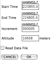 Figure 5 - Totality Run Confirmation Dialog. |
EFLIGHT then pre-computes all of the eclipse circumstancesand aircraft related information before anything is display or tabulated. Generation of eclipse circumstances and navigation data proceeds in temporallyincreasing order for the totality run and is a computationally extensivetask. While these data are being computed, a status message, indicatingthe instantaneous U.T. of the computation in progress, will be displayedin the title bar of the main window. During the computation somediagnostic information may be presented in the main window. Thisinformation can generally be ignored and will be cleared from the displaywhen the computation completes. A message informing of the completion ofthe COMPUTE TOTALITY RUN task will be presented when thecomputation has finished.
When the pre-computations are completed, if the DisplayGraphics box was checked in the Flight Definition dialog, a graphics outputwindow will be built (if it hadn't been from a previous Totality Run).
2) TABULATE TOTALITY RUN
The results of the totality run computation may be tabulatedin a scrollable text window (and exported to an ASCII file). Theformat of the tabular display is shown in Figure 6.
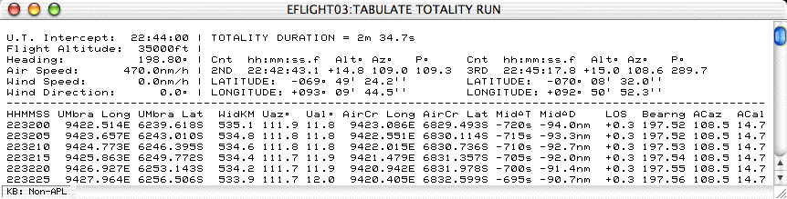
Figure 6 - Totality Run Tabular Output Window
The text output is organized in two sections: aheader and a table. The left side of the header region echoes backthe input parameters from the Flight Definition dialog. The rightsection provides the duration of totality and information on second andthird contact*. The U.T. of each contact, along wit the solar altitude,azimuth, and contact position angle is given, as is the location (latitudeand longitude) of the aircraft at the instants of the contacts. The tabularsection is presented in time order at the temporal resolution which wasspecified in the Flight Definition Dialog.
*NOTE: For very high precision contact determinations,a 1s temporal granularity should be used in computing the totality run.
The time-ordered table section is as follows:
HHMMSS = Universal Time (Hours, Minutes,Seconds)
UMbra Long = Longitude of the Center of the Umbra
UMbra Lat = Latitude of the Center of the Umbra
WidKM = Width of the UmbralShadow Projection in KM
Uaz = Altitudeof the Sun (degrees) from that point
Ual = Altitudeof the Sun (degrees) from that point
AirCr Long = Longitude of the Aircraft at the correspondingtime
AirCr Lat = Latitude of the Aircraft at the correspondingtime
MidDT = Time in seconds until/since mid-eclipse
MidDD = Distance to be flown (in units requested) to/from mid-eclipse
LOS = Line-of-Sitedeviation angle to the Sun w.r.t. aircraft windows (degrees)
Bearing = Instantaneous Bearing of theAircraft (degrees)
ACaz = The azimuth angleof the sun from the Aircraft (degrees)
ACal = The altitudeof the Sun from the Aircraft (degrees)
The geographical co-ordinates for the instantaneous centerof the umbra and position of the aircraft are formatted as specified inthe Flight Definition Dialog.
3) SELECT WAYPOINTS
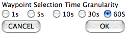
| The totality run is defined by a series of time correlatedwaypoints to which the the aircraft trajectory must conform both in positionand time. COMPUTE TOTALITY RUN determines a set oftarget points with a temporal granularity which is (in general) much denserthan is required to specify, a flight path to follow. The TotalityRun may be very closely approximated, by extracting a discrete set of waypointsfrom the more densely computed values. For nearly all eclipses (exceptfor those where the width of the shadow is extremely small, and also veryclose to the points of sunrise or sunset) waypoint densities on the orderof several minutes in time will not limit the accuracy achieved in theactual targeting of the aircraft. SELECT WAYPOINTS providesa simple mechanism for extracting target position waypoints from the computedtotality run. The selected waypoints, and associated local eclipsecircumstances are displayed in a pop-up window (the Selected WAYPOINTSwindow) and are used for incremental relative position updates in the EFLIGHTgraphical display of the totality run. TheSELECT WAYPOINTSmenu item should be selected after COMPUTE TOTALITY RUNhas completed. Select Waypoints will allow you to extract a subset of waypointsfrom a list (ordered by time) with a granularity of 5, 10, 30, or 60 secondsthrough the Waypoint Selection Time Granularity dialog (Figure 7).
After specifying the Selection Time Granularity, a WaypointExtraction Dialog (Figure 8) will be presented. This dialog willcontain a list of Universal Times corresponding to positions along thetotality run within the computed time window at the selection granularityspecified. The instant of mid-eclipse is pre-selected. Additionalpoints (by time) along the totality run may be selected (or deselected)by checking (or unchecking) the boxes adjacent the list of Universal Times. After clicking [OK] the extracted waypoints will be displayed ina Selected WAYPOINTS window (Figure 9).
| 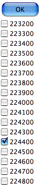 Figure 8. Waypoint Extraction dialog. |
4) DISPLAY TOTALITY RUN
Selecting DISPLAY TOTALITY RUN from theEFLIGHT menu creates a graphical output window which provides a continuallyupdating display showing the topocentric geographical circumstances ofthe total phase of the eclipse, and the computed track of the aircraft throughout the duration of the totality run.
TIME SYNCHRONIZATION
The totality run graphics display will update in one ofthree ways.
1. If RT SIMULATION was NOT selected,in the COMPUTE TOTALITY RUN Flight Definition dialog, thenthe graphical output will update asynchronously with respect to the computer'sclock. In that case, each successive graphic frame will be displayedwith an inter-frame cadence as specified by the Display Frame Delayin the Flight Definition dialog without regard to the system clock time.
If RT SIMULATION was selected, then aClock Synchronization Dialog (Figure 10) will be presented before the totalityrun graphic output begins.
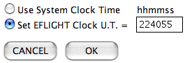
Figure 10 - EFLIGHT Clock Synchronization Dialog
2. If Use System Clock Time is selectedthe Totality Run display will commence when the System Clock reaches theUniversal Time of the first point computed for the totality run. After clicking[OK], the subsequent graphic output of thetotality tun will then be synchronized to the computer's system clock time.
In flight, it is imperativethat the computer's internal clock has been accurately set and synchronizedto a Co-ordinated Universal Time (e.g., through a network time server orGPS time reference).
3. You may set an "EFLIGHT Clock", independent of thecomputer's system clock but running at a real-time cadence, to which thegraphical output can be synchronized by selecting Set EFLIGHT ClockU.T. The "EFLIGHT Clock" will be set to the U.T. as specified(in HHMMSS format) in the Clock Synchronization Dialog. This timewill automatically be pre-set to one graphics frame delay period (as specifiedthrough the Flight Definition Dialog) before the U.T. of the first pointcomputed for the totality run, but may be over-ridden to any legal valueby user input. After clicking [OK], the subsequentgraphic output of the totality tun will then be synchronized to the "EFLIGHTClock".
Note: Option 3 (EFLIGHT Clock U.T.) isparticularly useful for simulating a real-time lapse-rate totality run,without the necessity of adjusting the computer's system clock to achievesynchronization with a "simulated" Universal Time.
DISPLAY GRAPHIC OUTPUT FORMAT
The EFLIGHT graphical output window is dividedinto a Map region (left) and a Text region (right). Five clocks, presentedin the title bar, provide absolute and relative time references. A sample "snapshot", frozen from the graphical output window, is shownin Figure 10 one instant of time.
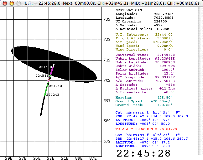
Figure 10. EFLIGHT totality run graphical output window
This particular example, corresponds a Universal Timeof 22:45:27 UT (as indicated both by the large UT clock at the bottom rightof the text region, and at the left of the graphics window title bar. In the title bar are four other incrementing clocks which indicate:
(1) how long until the next graphics display update
(2) how long until (or since) Contact II
(3) how long until (or since) mid-eclipse
(4) how long until (or since) Contact III
Map Region (Left):
The intersection of the shadow center with the geoidalsurface (see note on geodetic reference) at the altitudeof the aircraft (i.e., the path of centerline at flight-altitude) is shownalong with the path of the aircraft, and an approximate representationumbral shadow on a Mercator projection.
Umbral Shadow:
The projection of the umbral shadow, showing the instantaneousregion on the at-altitude geoidal surface in totality, sweeps acrossthe map region over the duration of the totality run. As a visualizationtool, and for display purposes only, the shadow boundary is approximatedas an ellipsoid. Shadow axis (and aircraft) positions, contact times, andother numerical quantities are derived with high precision independentof this approximation. The shadow boundary display approximationlooses high fidelity at very low solar elevations (e.g., near sunrise orsunset), but this does not affect the efficacy of any of the more rigorouslycomputed quantities which are displayed and tabulated. The umbralshadow projection is not shown for instants of time (also near sunriseand sunset) when the eclipse is non-central (i.e., when the apex of theshadow cone does not reach the flight-level elevated geoidal surface).
Mid-Eclipse Intercept Point:
The location of the point of mid-eclipse intercept, wherethe aircraft is instantaneously co-axially located in the umbral shadow(on centerline), is marked by a purple cross +.
Centerline:
The instantaneous positions of the center of the lunarumbra (defined by the lunar center of figure, not the dynamical centerof mass) are shown for each instant of time throughout the totality run. As time progresses the locus of these points discretely maps out the centerlineof the path of totality. At any instant of time each point (retainedin sequential frames) is displayed as a black dot (inverted as white whena point is immersed in the umbra). Points along the centerline throughwhich the umbra passes while totality is visible from the aircraft as itmoves along its track are circumscribed in green (or purple when withinthe umbra). In the example above, which is for a time very soon aftersunrise, the non-linearity of the point spacing due to the decelerationof the shadow in projection on the geoidal surface is readily apparent.
Aircraft Ground Track:
The ground track of the aircraft is shown throughoutthe totality run. Before the aircraft enters the umbra (or, moregenerally as the umbra overtakes the aircraft [except in some circumstancesfor supersonic flight]) these positions are marked in dark blue (invertedto yellow as the umbra later passes over). Points along the groundtrack corresponding to times when the aircraft is flying through the umbralshadow are marked in light blue (inverted to red when those points areoutside of the umbra).
Contact Times:
The instants and locations of second and third contact,marking the start and end of totality as seen from the moving aircraft,are annotated along the aircraft ground track as the aircraft passes thosepoints. The locations are marked by small black squares (invertedto yellow with the passage of the umbra over those positions) along withthe Universal Times at which the contacts occur. In addition, thepoints along the centerline corresponding to the instants when the aircraftenters and exits the umbra are also annotated with the Universal Timesof those instants.
Text Region (Right):
To the right of the map region, the circumstances of theeclipse and the aircraft flight parameters are updated at each incrementingtime step. The information is presented in five (color coded)sections:
2. (Light green). Staticecho of input parameters.
Universal Time of Mid-EclipseIntercept (HH:MM:SS).
Flight Altitude (in feet) aboveMEan Sea Level
True Air Speed in user-specifiedunits
Wind Speed in user-specifiedunits specified
3. (Purple). Dynamic. UmbralPath and Aircraft Circumstances and Positions.
Current Universal Time
Longitude of the center ofthe umbra at flight altitude
Latitude of the center of theumbra at flight altitude
Width of the umbral shadow(see UMBRAPHILE for definition) in kilometers
Solar Azimuth (degrees Eastof North) on centerline at current Universal Time
Solar Altitude {elevation}(degrees) on centerline above the astronomical horizon
Aircraft Longitude
Aircraft Latitude
Time in seconds to/from mid-eclipseintercept
Flight distance (ground track)in nautical miles to/from mid-eclipse intercept
Deviation from line-of-siteviewing angle to sun orthogonal to direction of aircraft
4 (Light Blue). Dynamic/Static.Instantaneous Flight Vector.
Aircraft Heading
Aircraft Ground Speed in unitsspecified for Air/Wind Speed
Ground Track Direction
5. (Dark Blue/Red).Static. Contact Information.
U.T. of second and third contacts
Solar Altitude {elevation}(degrees) above the astronomical horizon at contacts
Position angles of contacts(east from north) along solar limb
Aircraft Position (Latitude/Longitude)at contact times
Duration of Totality (minutesand seconds)
5) INTERRUPT(ing a Totality Run Graphic Display)
To interrupt a TOTALITY RUNin progress, select the INTERRUPT item from the EFLIGHT03 menu.
| Accidentally interrupting a totality run wouldbe very undesirable in flight! Therefore, after an INTERRUPT is requested a confirmatory dialog (Figure 11) will be presented whichmust be positively acknowledged before the temporally incrementing graphicaldisplay is terminated. Clicking [Continue Display] will resumethe graphical output. If RT SIMULATION was selectedin the Flight Definition dialog, the display will advance (to compensatefor the time lapse during the temporary suspension) to time re-synchronizethe graphical output. Clicking [*ABORT*] will terminate the graphicaldisplay at the current time step. The graphical display window willremain opened (but can be closed if desired), and the clocks in the titlebar will freeze at the moment of the interrupt request. |  Figure 11. INTERRUPT Confirmation Dialog |
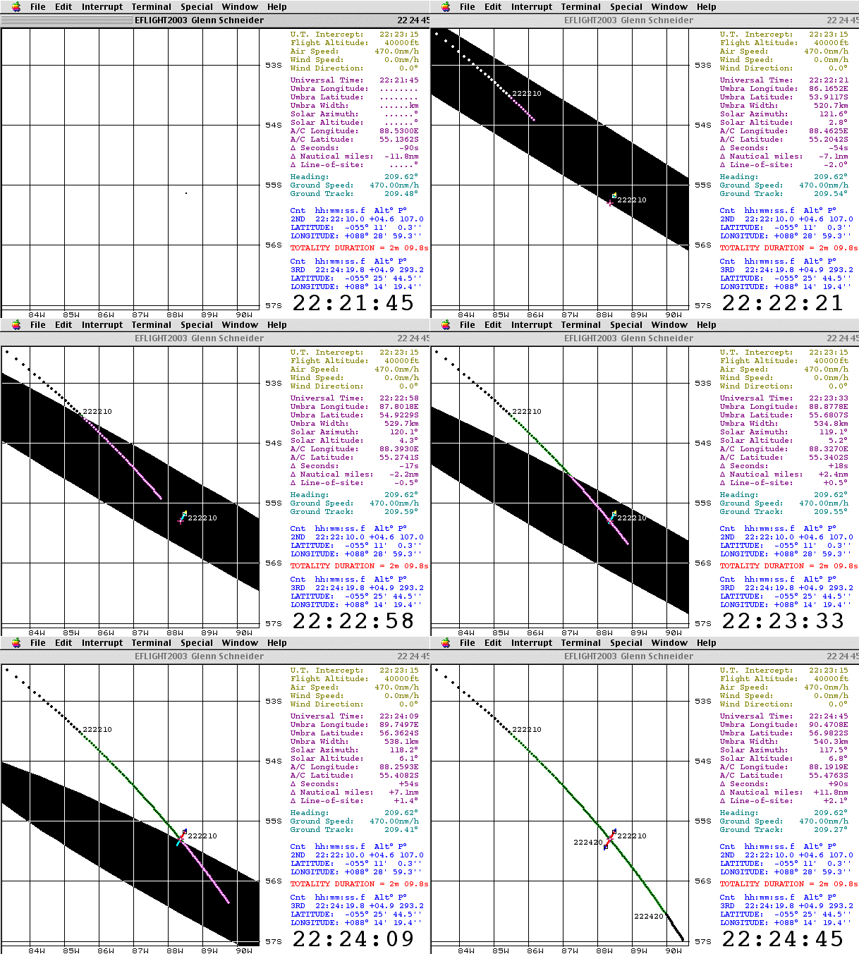
The EFLIGHT dynamic graphic display for a 40,000ft., 22h23m15s UT intercept of the 23 November 2003 total eclipse may beviewed, as an example, to gain a better understanding of the graphicaloutput format. This "movie" was actually generated with an earlierversion of EFLIGHT (and thus the graphics display is somewhat different)but is shown to illustrate the concept.
In this example an intercept profile spanning (-1.5, +2)minutes centered on 22:23:15s U.T, (shortly after sunrise) is developedto fly a course of constant heading over those three minutes to have thesun "straight out" the aircraft sun-side windows at mid-eclipse. As the animation/movie opens at 22:21:45 U.T. the center of umbra has notyet "touched down" 40,000 ft. above the surface of the earth. Hence,as the first time steps are displayed only the changing location of theaircraft (and the intercept point) is annotated in the map region, andparametric values associated with the umbra in the text region are blankedout. Eight seconds later at 22:21:53 U.T. the umbra-center reaches40,000 feet above the surface of the Earth, and that location is markedinside the approximate projection of the shadow which then appears. At that point the aircraft is 10.7 nautical miles from mid-eclipse interceptwhich it will reach in 82 seconds by flying a true heading of 209.6°at a ground speed of 470 nM/hr (with no wind). Second contact hasbeen computed to occur 17 seconds later at 22:22:10 U.T. Over those17 seconds, as the shadow moves to the south east, the umbral projectionon the geoidal surface decelerates as can be seen by the decreasing pointspacing along the developing centerline. At 22:22:10 U.T. the positionof the aircraft is annotated (as is the corresponding point along the centerline)as totality begins for in situ observers. The evolving path of theeclipse, and flight of the aircraft can then be followed through mid-eclipse,to third contact, and beyond to the end of the requested time window.
6) COMPUTE COURSE
For planning (but mostly obviated by in-flight navigationsystems) EFLIGHT provides a facility for easy producing the time-criticalrouting to approach the first point on the TOTALITY RUNfrom some pre-run location. This is done through the COMPUTECOURSE menu item and dialog as shown in Figure 11.
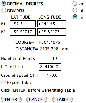
Figure 11. COMPUTE COURSE dialog.
COMPUTE COURSE will produce a set of time-orderedway points to be followed to get from point 1 (P1) to point 2 (P2). As a matter of convenience, after generating a TOTALITY RUN,the aircraft coordinates of the first point for the run is transferredto P2 in the COMPUTE COURSE dialog. The time at whichthe aircraft must be at P2 is the time corresponding to thefirst point in the totality run, and is the U.T. for the last point (U.T.of Last) in the COMPUTE COURSE waypoint table. Thistime is also automatically transferred to the COMPUTE COURSEdialog after generating a TOTALITY RUN. It is likelydesirable to approach this point sometime prior to the critical "must beat" time, to allow for any unanticipated delays em route, and to executea hold pattern at that position until the requisite release time. The U.T. Last field may be entered manually, to build in as long a holdtime as desired. These co-ordinate fields, as well, may be manually over-writtenby entering whatever coordinates are desired,. Coordinates may beentered in decimal degrees or DDMMSS format as specified.
After the coordinates are entered first click the[ENTER] button. This will update the COURSE = and DISTANCE = values shown in the dialog. The course is the great circle heading in degrees from P1 to P2 (flownfrom P1), and the distance is in the units which were selected (upper right). To generate a table of intermediate way points (e.g., figure 12), thenclick [TABLE].
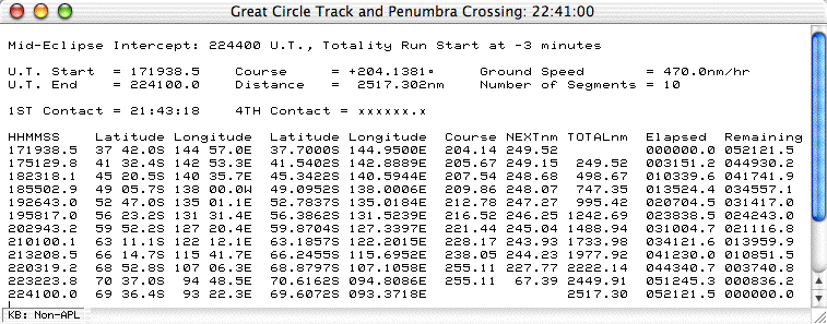
Figure 12. COMPUTE COURSE Text Window output.
The title bar of the text window containing the COMPUTECOURSE table indicates the Universal Time at the completion of the computedtrack from P1 to P2.
The first line of the table header gives the U.T. of mid-eclipseintercept, and the time before that intercept (in minutes) the Totalityrun begins.
The second line gives the U.T. the aircraft would haveto leave P1 and the great circle heading to fly, given the ground speed(as computed based upon earlier airspeed and wind information entered inthe COMPUTE TOTALITY RUN Flight Definition dialog).
The third line gives the arrival time at the end of thegreat circle track (and start of the totality run), and the total distanceflown, as the number of segments in the table which then follows.
IF the aircraft crosses the penumbral shadow boundaryalong the track from P1 to P2 the estimated crossing time, which is theinstant of 1st or 4th contact is indicated (as appropriate).
For each instant of Universal Time in the table, the Latitudeand Longitude of the aircraft is given (in two formats as shown), as wellas the course from that point (in degrees), and the distance to the nextsegment is indicated. Also shown is the running distance and time fromstart, and time remaining to the end of the course.
COMPUTE COURSE critically seamstogether the approach to the Totality Run and the start of the TotalityRun. For the actual Crydon/QANTAS and TravelQuest/LanChile flight,the plans developed have the aircraft reaching a "hold" point ahead ofthe start of the totality run before the critical time (by nominally 15- 20 minutes) to allow for any unforeseen in-flight delays.
7) QUIT
To terminate EFLIGHT select QUIT from the EFLIGHTmenu.
Summary
This page is intended to briefly introduce you to EFLIGHT,and to give you an idea as to how it was used to develop baseline flightscenarios for the Croydon/QANTAS and TravelQuest(Sky & Telescope)/LanChileAntarctic eclipse overflights. This is not intended to be afully comprehensive user's guide, since I suspect the number of potentialusers (other than myself) are rather small. However, if you consideryourself a smitten umbraphile, I suspect the EFLIGHT concept mightbe of interest to you (particularly if you have read this far down thepage). So... now you know.
What's next? EFLIGHT continues to evolveto support the 23 Nov 2003 eclipse flight planning and execution. Indeed, it was recently tested in a three hour session in the QANTAS B747-400simulator in Sydney by QANTAS Senior Check Captain John Dennis (who willbe the pilot in command for the Croydon/QANTAS flight) and myself as wedry ran the eclipse flight. (As a result of that simulator session, a few"tweaks" were made to the user and display interfaces, to make its real-timeuse in conjunction with the requirements of the 747 Flight Management Systemmore seamless).
If you are seriously contemplating a airborne observationof this eclipse, or of a future eclipse and would like to take advantageof EFLIGHT as a planning and in situ execution tool then contactme. Unlike UMBRAPHILE,however, I am not freely giving it away, primarily because to use it optimallyrequires a fair amount of detailed familiarity. I would, however,be very happy to work with like-minded eclipse chasers in defining andplanning future airborne eclipse observations using EFLIGHT - maybein exchange for a sun-side window on your aircraft.
Cheers,
Glenn Schneider
Initially posted: 15 February 2002
Updated: 26 July 2003
Return to the UMBRAPHILEHome Page