Sunset Expedition to Fort Grey, Australia
E-MAIL WEB | E-MAIL WEB | E-MAIL WEB |
Africa vs. Australian Coast vs. Australian Outback
The path of the total solar eclipse of 04 December 2002spans two continents, Africaand Australia.The maximum duration of the total phase of the eclipse in Africa exceedsthe appx. 1/2 minute one would experience in Australia, a factor of threeon the Mozambique coast as the lunar shadow heads out over the Indian Ocean. And, the maximum elevation of the Sun at mid-eclipse in Australia (at thecoast) is only 9-degrees, and declines as the path progresses inland towardthe outback, compared to a maximum of 45 degrees on the east African coast. If duration and solar elevation were the two principal factors in selectingan eclipse observation site the choice would be obvious. However,these are not the overriding criteria.
To maximize the probability of seeing an eclipse considerationof the climatology of the target areas, and the need for maintaining mobilityand flexibility, are paramount. Noting, of course, the caveat that"climate is what you expect, weather is what you get". The lateris particularly true as localized weather phenomena in regions affectedby the decline of solar insolation during an eclipse are not well representedby statistical examinations of climatalogical (or meteorological) data. None-the-less, it is quite clear that potential for near-sunset clear skiesthe inland regions of Australia at that time of year exceed thosefound along the track anywhere in Africa.
It has been suggested that in a few isolated spots onthe African continent, such as near Beithbridge in Zimbabwe, that the chanceof "clear skies" might be as high as 60% based upon the normal mid-morning"mixing" model for cloud convection and formation. During this timeof year, the onset of the rainy season with higher humidity, cold-air advectionbrought on during the eclipse muddies the waters (if I may mix metaphors,if not the atmospheres) and the likelihood of cloud formation would increaseover the nominal and usual scenario. It would be wise for anyoneconsidering an African observing venue to remain aggressively mobile. But,as many of us learned first-hand in our treks to the 21 June 2001 eclipse,where the path was very similar (in Africa) to that of this years event,mobility is particularly "challenging". And, given the recently acceleratinginstability in Zimbabwe (in particular) this, sadly, could make aless than desirable choice for foreign travelers.
In contrast, the inland regions of Australia eastwardof the Torrens salt lake bed offer very dry conditions during the australsummer season, with mean cloud cover reaching as low as 20% (and best atthe eastern extremedy of the path). On the Australian coast cloud covermay be "expected" at about 50%, though here too convectionally driven coolingof the late afternoon moist sea air would likely increase the likelihoodof coastal cloud. As one moves eastward along the path of totalityin Australia the altitude of the sun declines, so the "likelihood" of acloud along the line-of-site increases, which would bias these statistics. When the low solar elevation is taken into consideration, inland sitesare still significantly preferential to the coastal region. For thesereason, evaluating the likelihood of a view of the sun unobscured by interveningcloud, the eastern end of the path of totality in Australia "shines" asthe preferential location for an eclipse viewing site. With the abilityto flee westward (i.e., remaining aggressively mobile) to react in situto local weather conditions, this is where I will head for the 04 December2002 eclipse.
Quality, Not Quantity
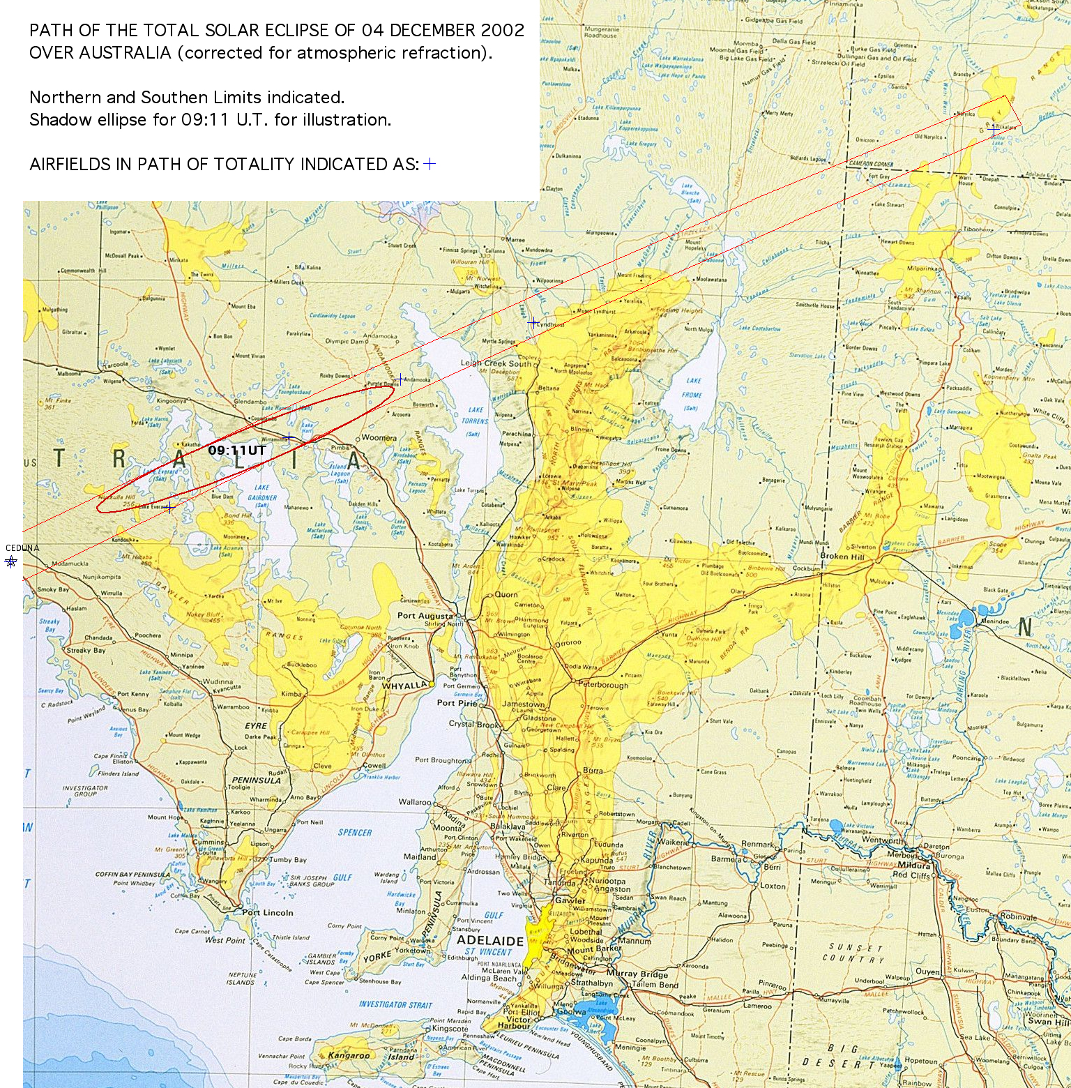
For some eclipse chasers the mantra is "duration, duration,duration". For me, like a real estate agent (which I am not)it is "location, location, location". At this point it wouldbe useful to look at a more detailed MAPOF THE PATH OF TOTALITY OVER AUSTRALIA (2.3Mbytes, patience please).Electing to observe from Australia path means accepting a durationof totality of approximately half a minute. From the coast, nearCeduna, the centerline duration of totality is about 33 seconds. At the (refraction corrected*) sunset point, near Tickalara,it is about 24 seconds. One can look at this as either a half-empty,or half-full glass, depending upon your philosophy of life. I.e.,this can be viewed as a "loss" of nine seconds (27% of the duration oftotality at Ceduna), or as a weather-driven opportunity to witness a totalsolar eclipse at (or very near) sunset. This is something I havealways wanted to experience, purely from the esthetic (some may say ethereal)perspective, but was unwilling to offer up a sacrificial eclipse. Indeed, for all other eclipses I have observed the regions at or near thesunset (or sunrise) points were always contraindicated due to weather (aswell as, secondarily, duration). To see the totally eclipsed sunjust over the horizon, looming large by the "moon illusion", in a conicalwedge of darkness from the relatively narrow (appx. 25km wide) umbral shadowstretching through a nearly horizontal plane in the atmosphere is a tantalizingthought. Then, at third contact the "lower" edge of the sun approachesthe horizon near the point where the diamond ring from the soon-to-setvery thin photospheric crescent will appear, and the umbral shadow liftsstraight "up" into space. Yup, I'll be there. Any other takers?
* The position of the sun and moon in the sky [and hencethe projection of the moon's shadow on the Earth] are affected by refractionthrough the atmosphere. In computing local circumstances at the sitesconsidered here I have applied a simple refractive "correction" model,which I have previously described HERE. Such corrections are generally very small, but cannot be neglected forvery low solar elevations. This model used, however, is likely inaccurateat high precision at the most extreme eastern end of the path (near Tickalara)since the temperature (and pressure) profile of the atmosphere will likelybe different than considered. Further refinement is in work.
TOPOGRAPHIC MAPS (250,000:1), Path Lines and LocalCircumstances
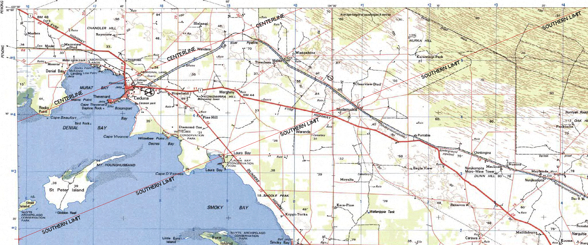
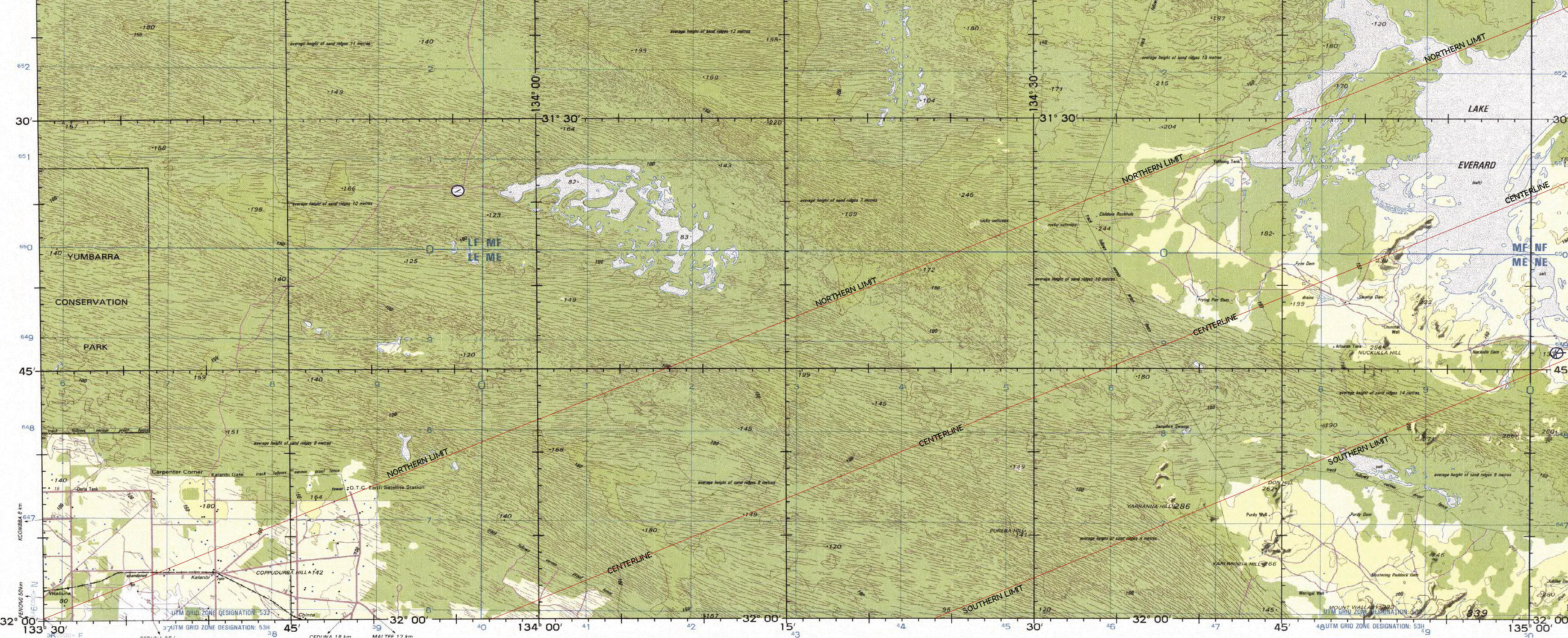
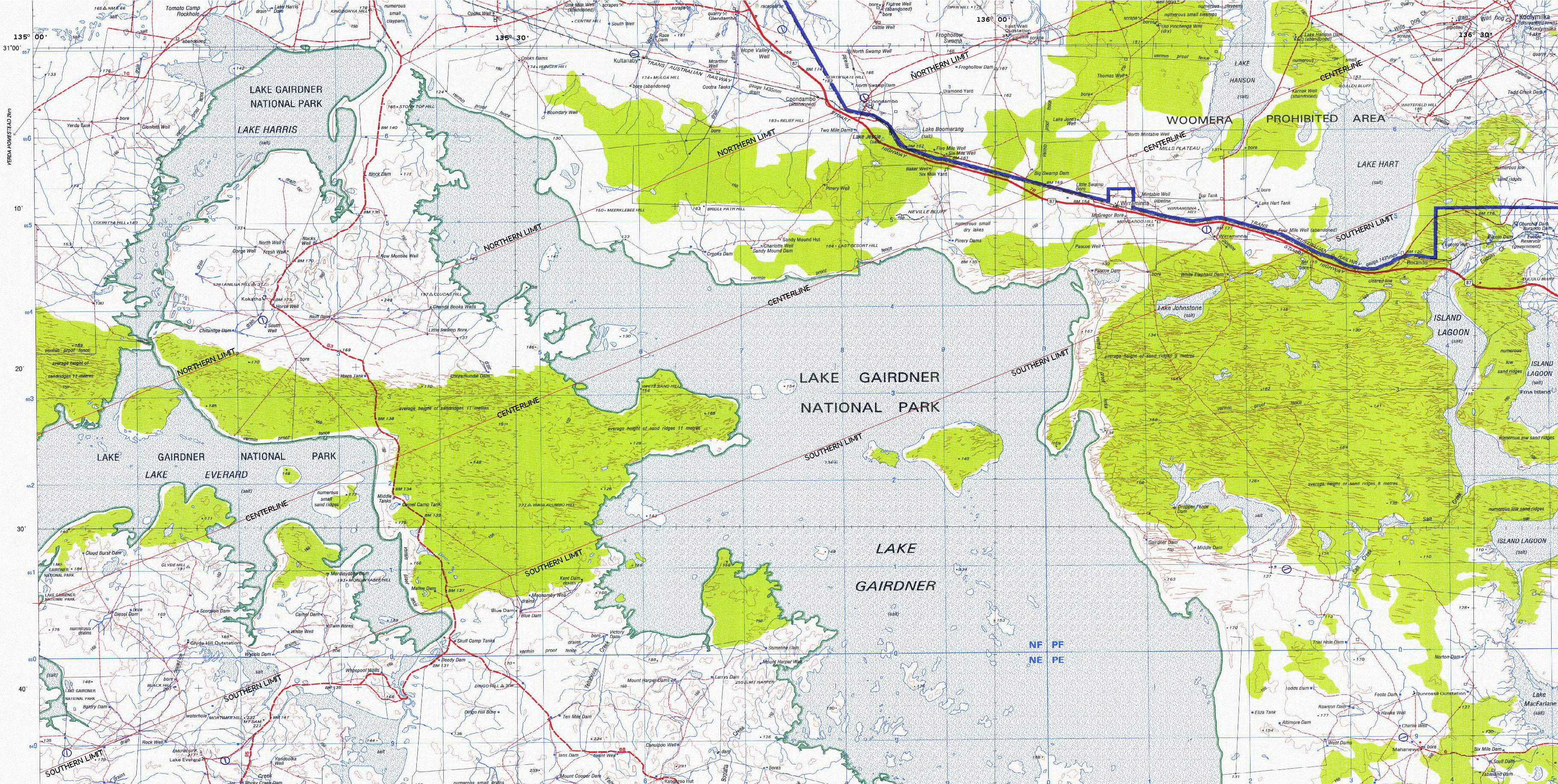
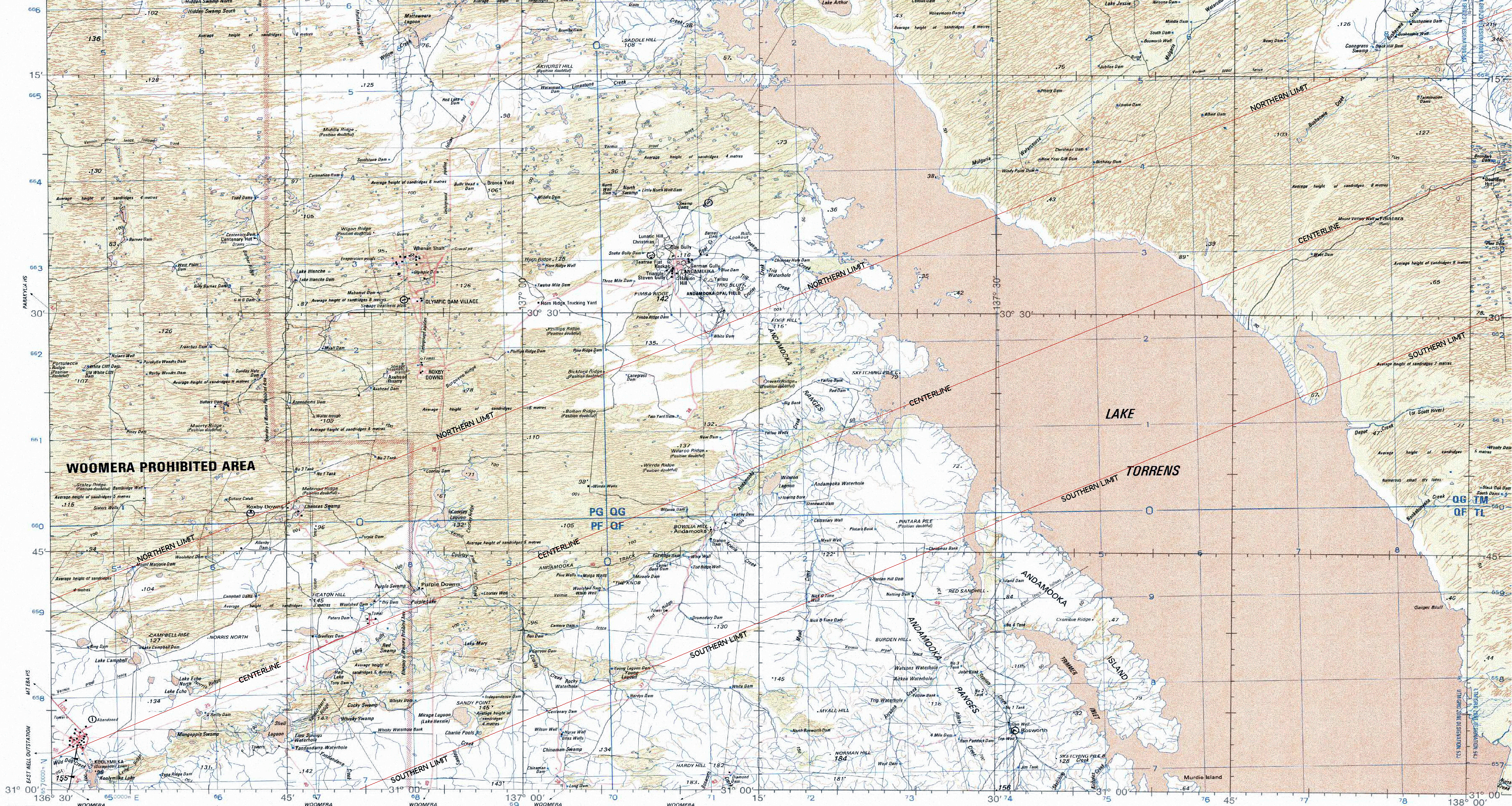
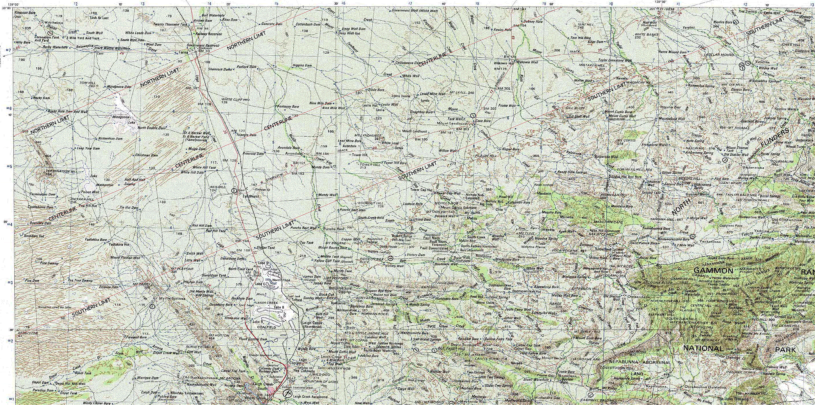
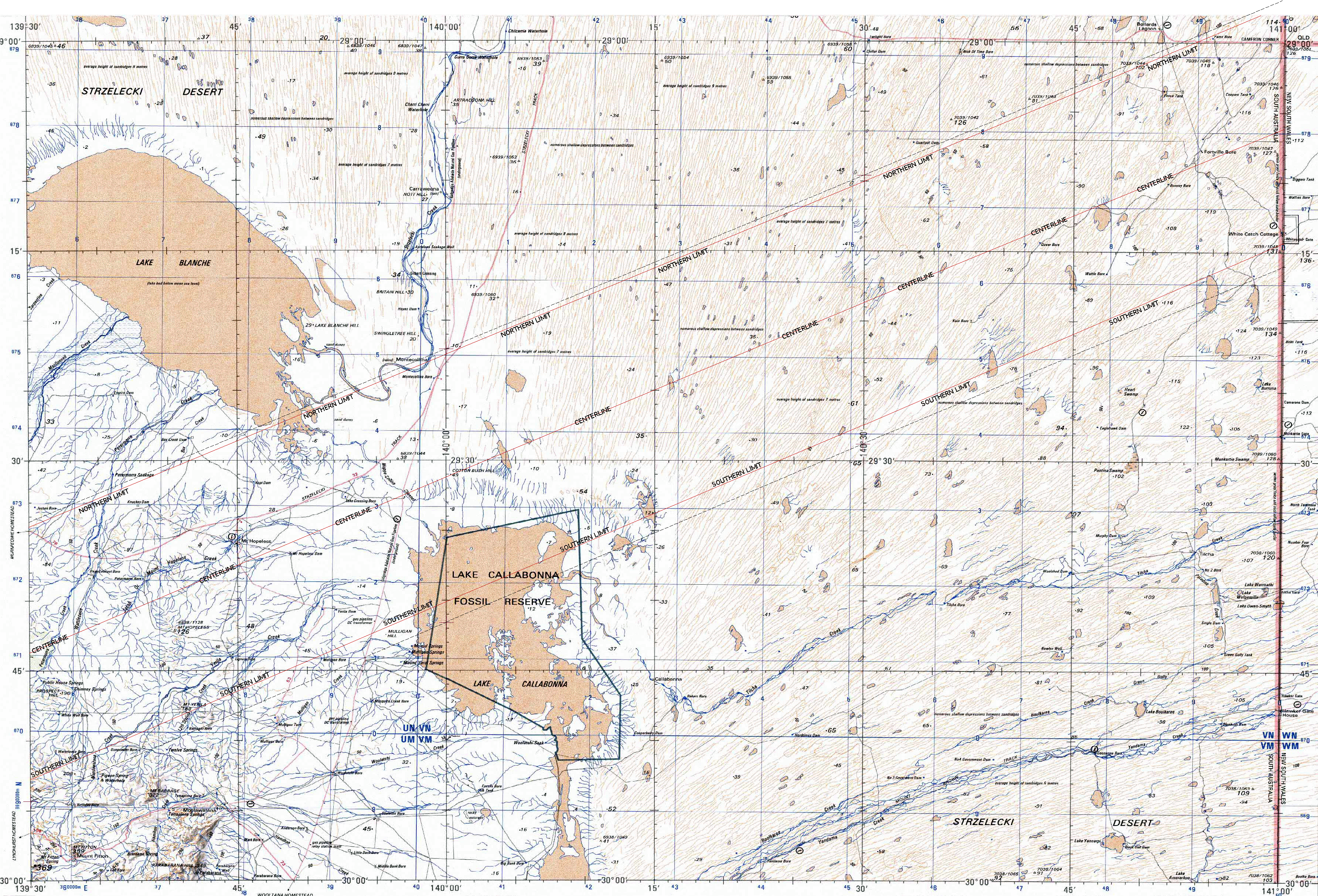
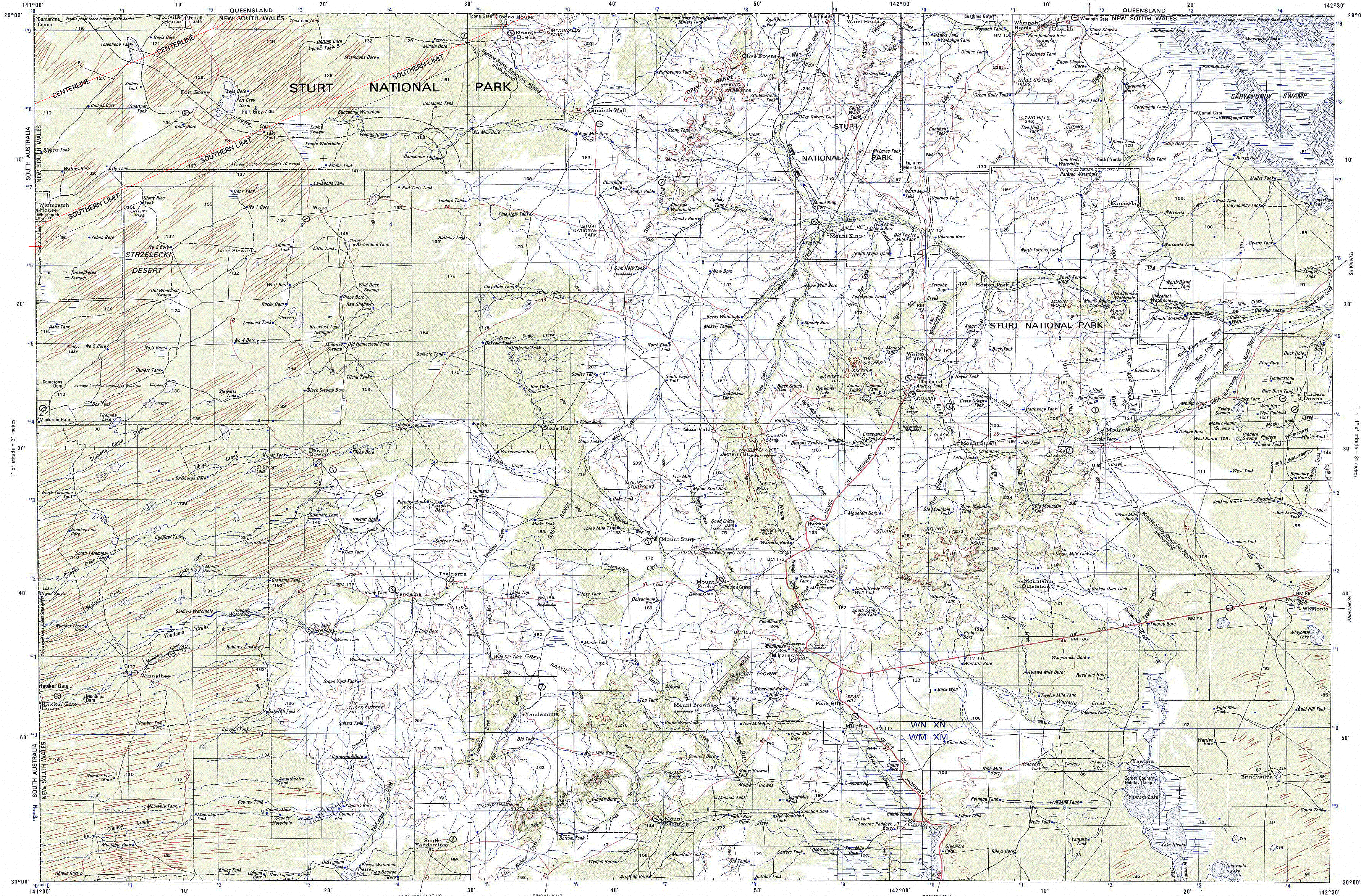
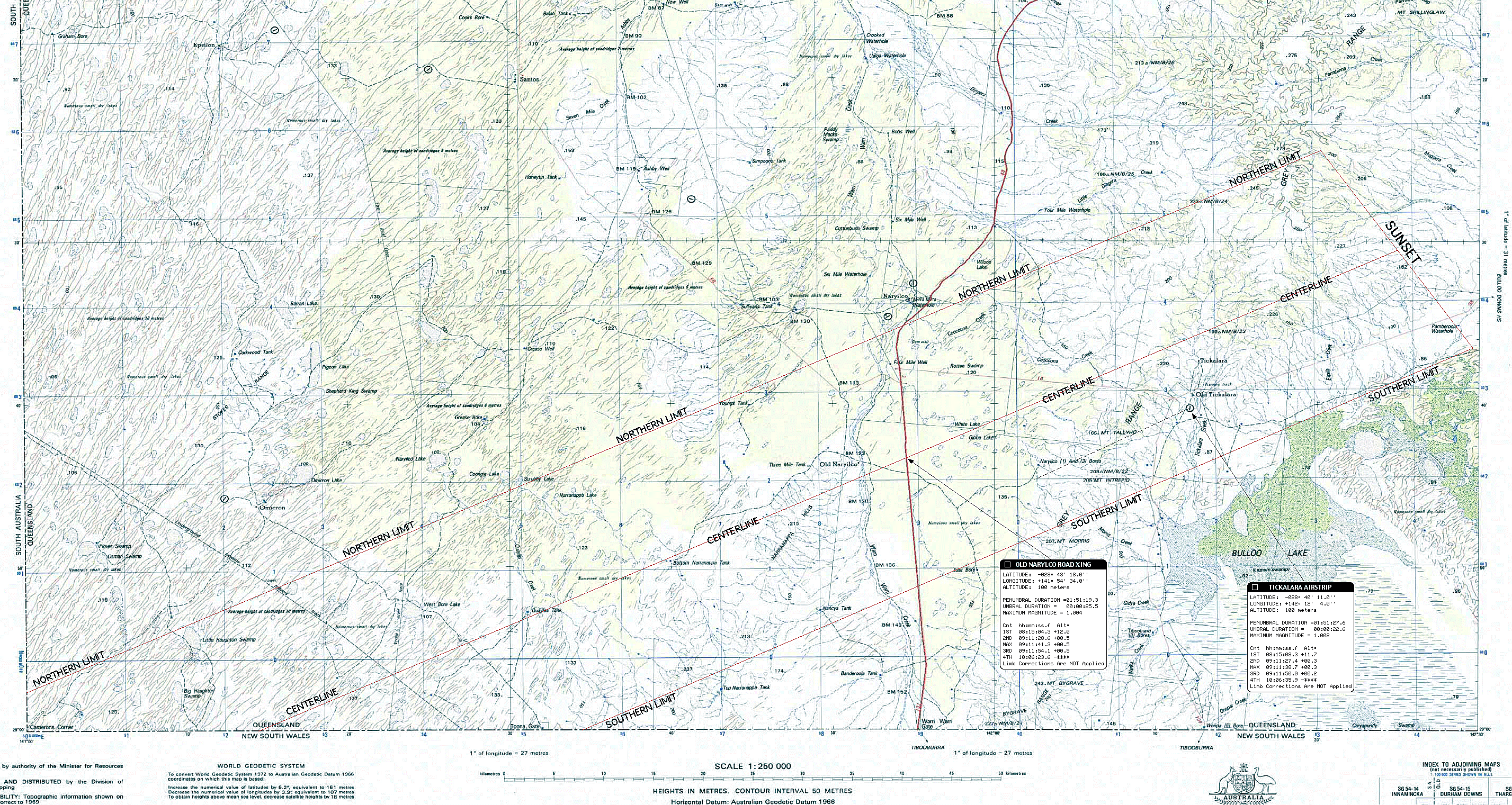
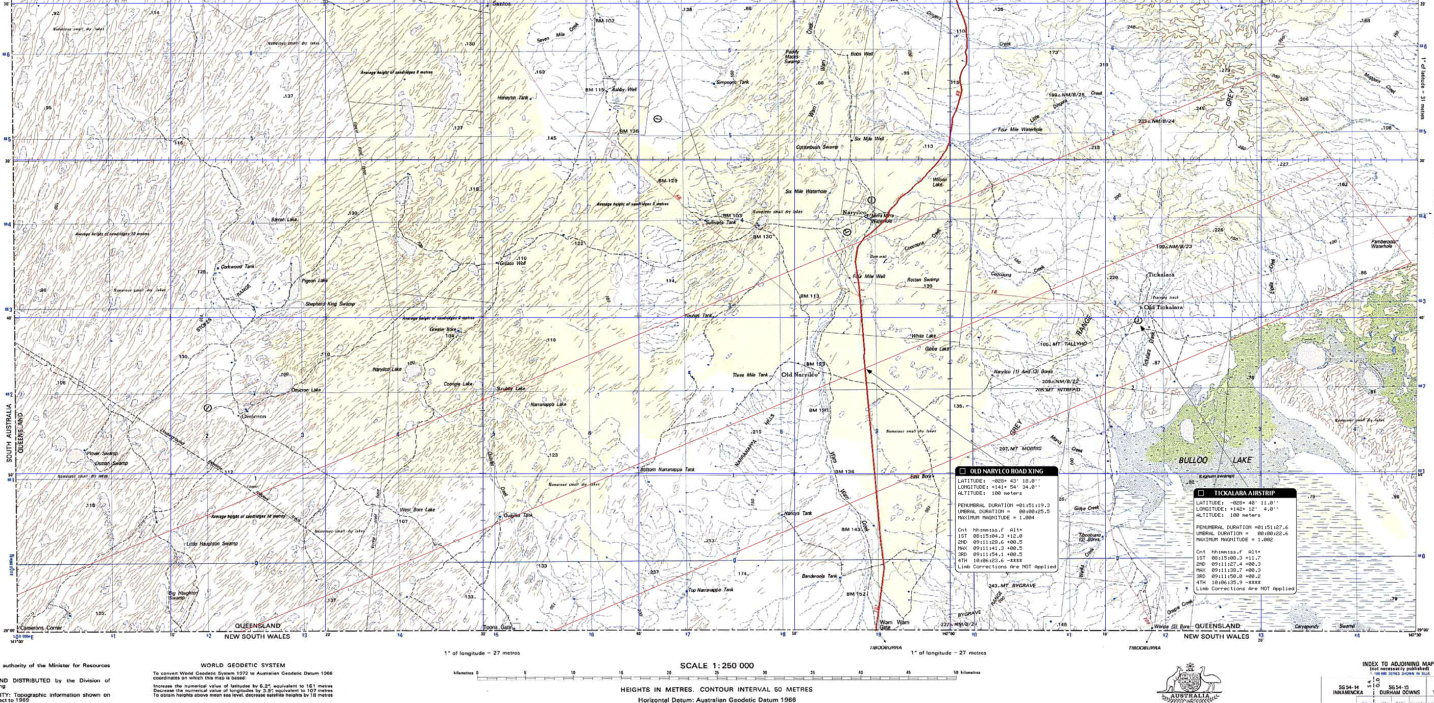
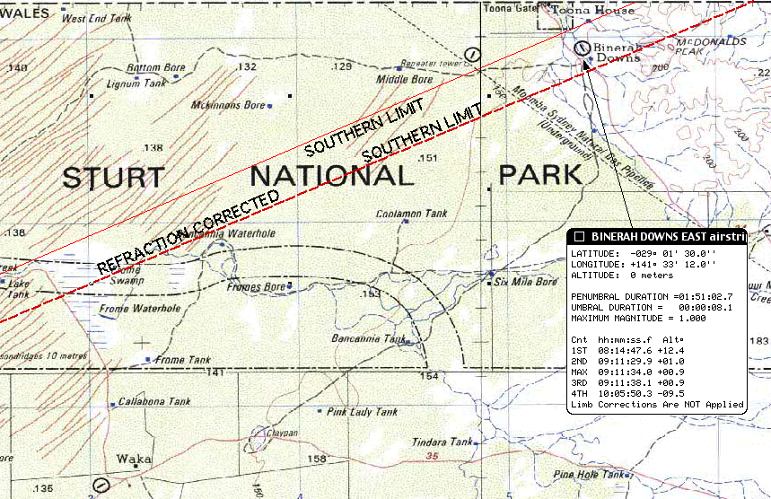
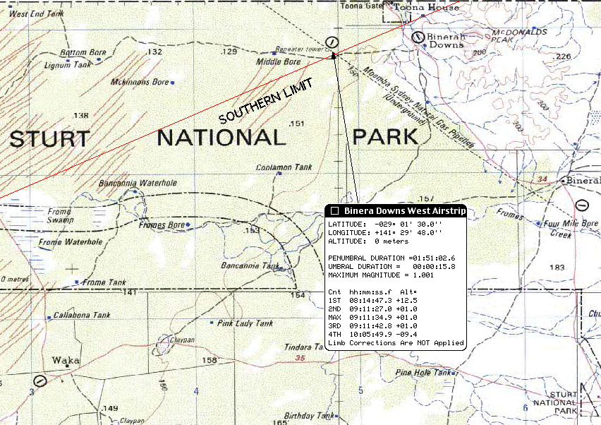
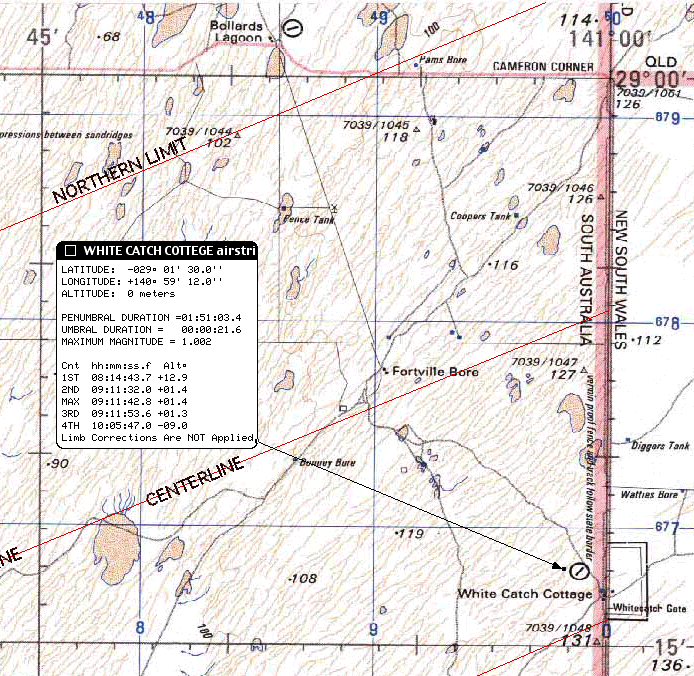
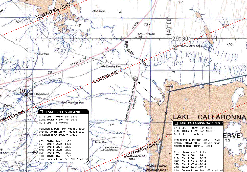
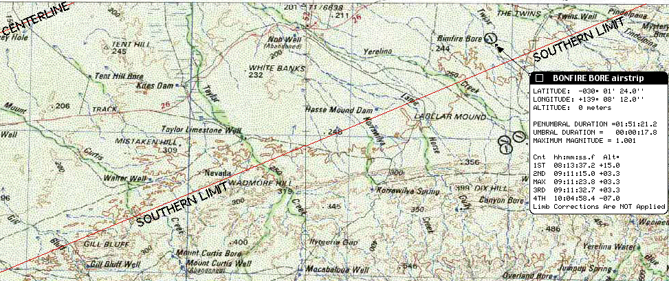
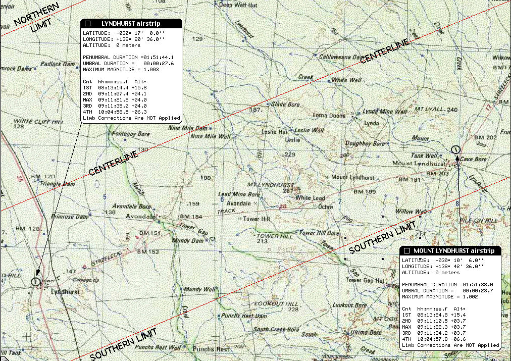
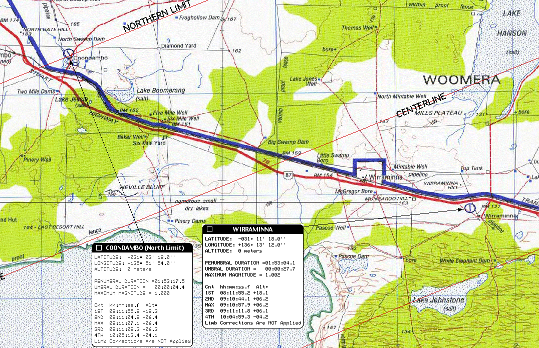
To facilitate discussion, the path of totality over australiahas been overplotted on 250:000:1 topographic charts. To see/downloada chart click on the longitude range of interest. Northern limit,Southern limit, and Centerline have been indicated (annotated red lines)on all charts.
LONGITUDE RANGE CHART NAME AREA COVERED (download size)
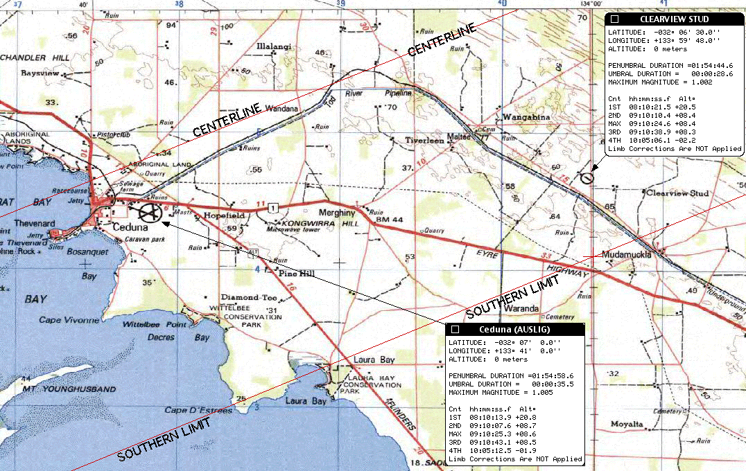
133° 00'E - 134°24'E (Streak Bay) Denial Bay, Ceduna (1.7Mb)
133° 30'E - 135°02'E (Childara) Kalanbi, middle-of-nowhere, lots-of-nothing(4.5Mb)
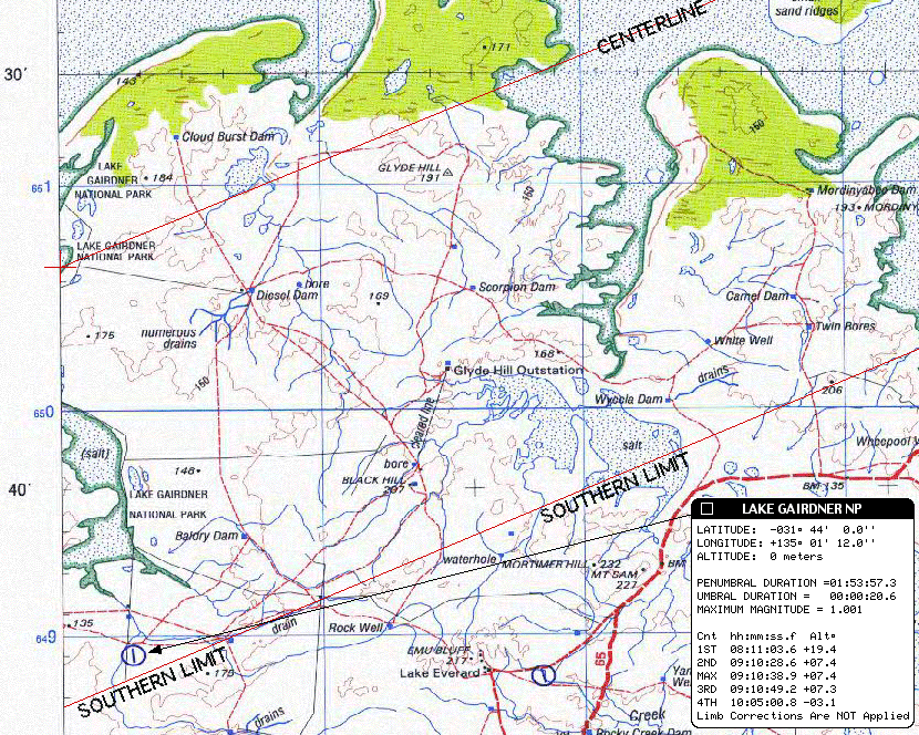
135° 00'E - 136°35'E (Gairdner) Lake Gairdner NP, Wirraminna (4.9Mb)
136° 30'E - 138°03'E (Andamooka) Purple Downs, Andamooka, Lake Torrens (4.7Mb)
138° 00'E - 139 °14'E(Gammon) Lyndhurst, Mt. Lyndhurst (3.8Mb)
139° 30'E - 141°02'E (Callabona) Mt. Hopeless, Lake Callabona, Cameron Corner(4.7Mb)
141° 00'E - 142°30'E (Milparinka) Fort Grey, Strut NP (5.2Mb) {entire chart}
141° 00'E - 142°30'E (Tickalara) Old Naryilco, Tickalara (2.2Mb)
Details: The overplotted (red) limit and center lines on thesecharts have been computed conservatvely in accord with the system adoptedby Espanak and described in NASA TP 2001-209990. In particular, for this purpose only:
(a) a value of k=0.272281 is used, though this is in disagreement withthe value of k=0.2725067 adopted by the International Astronomical Union.
(b) no corrections are made for the displacement of the lunar centerof figure with respect to its center of mass.
(c) no corrections have been made for atmospheric refraction.
Thus the red center and limit lines on these charts should be in veryclose agreement to Tables 7 and 8 in the TP 2001-209990.
Elsewhere, in computing local circumstances for the particular placesas discussed and tabulated on this page (and in links to this page):
(a) the IAU adopted value of k=0.2725076 is used.
(b) a correction of (+0.50", - 0.25") has been applied to the latitudeand longitude of the moon to compensate for the displacement of the meancenter of figure from the dynamical center of mass.
(c) the displacement of the path due to atmospheric refraction hasbeen compensated for by a simple approximate correction assuming a "standard"atmospheric model and STP at seal level. This approximation is likelyto loose high fidelity at very low solar elevations for in situ air-pathprofiles which deviate from the assumed model.
The net effect of applying these corrections (b) and (c), and usingthe IAU value of "k" is illustrated on the Gammon, Calabona and Milparnikacharts by the dashed black lines "above" and "below" the limit lines computedas per TP 2001-209990. To generalize, applying these correctionsresults in limit line mean displacements of displacement perpendicularto centerline of appx. 0.6' to the north and 1.6' to the south in theseregions (though, obviously, dependent upon topographic location). The difference is small, but not negligible at/near the northern/southernlimits. For example, the airstrip at Binerah Downs (Milparnika topographicchart) is about 1km outside of southern limit by the TP 2001-209990 convention,but about 1km inside of southern limit as computed with the correctionsdescribed. In either case, further location dependent correctionsdue to irregularities in the lunar limb profile (of about these spatialamplitudes) must be applied when high precision predictions are required. The primary effect of (c) is to displace the path along the anti-sun azimuthand "extend" the path eastward by about 60km.
The "Plan" - from the ground up
Last year our small but dedicated band of die-hard Umbraphileshad such successin Zambia, that I advocated something similar for Australia. Again, no touristy "if it's Tuesday it must be Melbourne" and "oh, by theway there is an eclipse" whirl-wind sightseeing trip with a lot of tag-alongsfor whom the eclipse is of secondary import. No. Rather, anucleus of us, the enlightened, those who advocate "eclipse or bust" andwill stand by that until the last coronal photon wanes. Of coursewe would welcome a "first timer" or two, if they are truly motivated bythe eclipse. Clearly some of us would want to avail ourselves ofthe opportunities to explore "down under" but not at the expense of, oruntil after, the Champaign cork has popped, the egg creams have fizzed,and we are scratching our heads about how we get to Antarctica in 2003. So from hippos to 'roos. Are you game? The game is indeed afoot.
The "plan" in detail is still evolving, but inconcept is now relatively mature. Michael Gill and I had been iteratingthis for quite a while and we were driven (motivated) by a desire to observetotality from very near sunset at centerline. Recently, we fell inwith Joseph Cali, an Aussie some of you may know from the Solar EclipseMailing List, who has first-hand familiarity with many of the logisticsand transport "issues" which leap to mind. And, Joel Moskowitz hassaid "count me in", and thus, this is now our small band of die-hards headingfor the hottest place I know of outside of Tucson. By the way by "verynear the horizon", I mean we target for the Sun still being above the horizonat third contact, by about 1-1/4 degrees. Less than that, well, we'renot absolutely crazy (though some may disagree) - but read on.
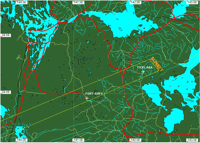
Before getting too specific (which I will) it is worthlooking at the large scale path mapnow if you have not done so. This is a "road map" of the region coveringthe path of totality with northern and southern limits overplotted. The path (which has been corrected for atmospheric refraction) "ends" atsunset just NE of Tickalara. You will note a number of blue "+"'sin the path. These are airfields in the path of totality, more onthat later too. You probably have noted the paucity of roads andthe sparseness of the road network at the eastern end of the path. Thus, the "basic" plan is that we will converge in Canberra (where JoeCali lives) on November 30th. There we will pick up (at least) two4WD vehicles. Joe has his own, and we are going to rent a campervan,eitherthis model or something similar to travel to our "prime" pre-selectedviewing site, which is on centerline near Fort Grey. Two vehicles, of course, is a minimum. One would be downright foolhardy as we cannot risk a vehicle breakdown stranding us outside of thepath of totality. If more people (within limits!) end up joiningus in this venture we will up the number of vehicles.
Conservatively, we would make our way to and basein Port Augusta (or Broken Hill) two days before the eclipse. IFat that time of our departure to Fort Grey there is a clear and unambiguousreversal in anticipated weather conditions we would head westward towardCeduna. IF not, however, we would take the following route, with drivetimes noted by Joe Cali (who has provided very helpful comments regarding4WDtravel in the area which should be seen by anyone considering overlandtravel along the path of totality):
a) Port Augusta SE to Peterborough
JC: 120km About 1.5 .- 2 hrs
b) Barrier Highway NE from Peterborough to Broken Hill
JC: Good condition, sealed & fast 270 km 3 - 5 hrs
c) Silver City Highway N from Broken Hill to Tibooburra
Tibooburra is our"gateway to totality" (please be sure to see this link for more information). It is one of (if not the) most remote, and hottest, towns in Australia. Tibooburra is outside of the path of totality, but is the logistical "local"staging point for our final assault. .
JC: Distance 340km. Time 4- 6 hrs. Condition - pretty good and sealedpart of the way. Conditions get a little worse the further north you go.In a top heavy camper 4wd you probably shouldn't travel over 60-70km perhour once you hit the unsealed roads.
d1) Tibooburra to centerline near FortGrey (about two hours drive time).
{Joe also provides additionaldrive time info for a more direct routing from Canberra.}
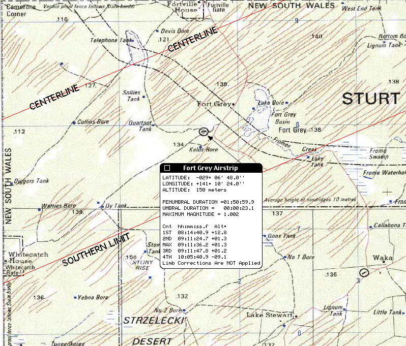
FORT GREY. Fort Greyis in SturtNational Park. The elevation of the Sun, there, is 1.3 degreesabove the horizon at mid-eclipse and might offer a bit more comfortable"breathing room" against any horizontal obstructions than sites furtherEast. Joe Cali had summarized "I checked the maps. The airstrip and thepoint where the road crosses the centerline have low horizons. FG airstrip:10m high sandridges 11 kilometres away @ az = 243deg, Ft Grey: 10m highsandridges 15 kilometres away @ az = 243deg. There will be similar 10msand ridges nearby." and indeed the Milparinka topographic chart confirmsthis. We could climb the ridges for a bit of extra elevationif necessary. This site is accessibleby a road and may be seen on a larger arearoad map also showing its location w.r.t. Tickalara. Note:From centerline, 5' to the north of the Fort Grey landing strip along theroad landing strip along the road, the duration increases by 3 seconds(to 26.2 seconds prior to limb corrections).
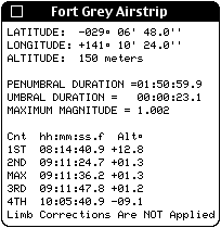 Localcircumstances (left) for the Airstrip at FortGrey, which has two 900 x 30 runways, heading 8/26 and 3/21, (informationgraciously provided by: Bill Harvey, Public Affairs, Department of Transport& Regional Services, (02) 6274 7860, Bill.Harvey@dotrs.gov.au, andGary Oldman, Information Technology Manager, Royal Flying Doctor Service(SE Section), Ph 08 8080 1718, Fax 08 8088 4536, gary.oldman@rfds.gov.au).The somewhat off-centerline airstrip is in the path of totality and locatedat: Longitude = 141° 10' 24"E, Latitude = 29° 06' 48"S, with theadvisory "sand hills in vicinity of strip".
d2) Continue North (unimproved?) road to centerline justeast of Old Nariyilko
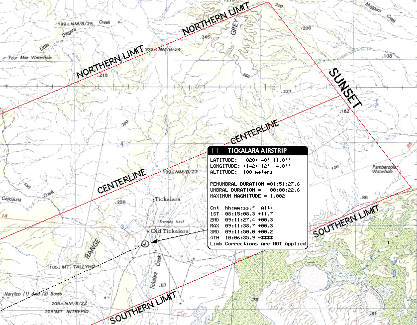
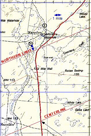
OLD NARIYLKO. "Bottom Narrabappa Tank", on centerlinenear Old Nariylko and is is a possible viewing site. However,with the sun only 1/2 degree above the astronomical horizon , and <appx. 1/5 degree above the local topographic horizon, at mid eclipse. Thatwas a bit too close for us, and we vetoed this site in favor of the slightlymore westerly Ft. Grey. Do see the information on this, the Tickalara/OldNariyilko/Bottom Naranappa site, though. And, also, a 250:000,1topographic map of the sunset end of thepath of totality near Tickalara.
The Backup - The Escape (Plane)
Once at a specific site in the path of totality, particularlyfurther toward the eastern end of the path, an overland "escape" to avoidunexpected clouds on eclipse day would be difficult. The rate whichone could back-track to the west by going overland off-road (witha 4WD of course) is likely < appx. 10km/hr. Indeed, fleeingeven a "modest" distance from Fort Grey, off-road could take much too long. We could backtrack through Tibooburra (see this MAPtoo) to reach another centerline (or at least in-the-path site, but wereally would want to be able to move further faster. Hence: the escapeplane - a light aircraft standing by at, or very near, ourPRIME observing site capable of transporting us from there to another in-the-pathsite on very short notice. The plane would be pre-positioned at theairstrip at (or very near) our prime site and we would use it only if necessaryto fly us to an alternate, pre-selected, site to escape clouds. Ofcourse this would mean leaving our vehicles at the prime site (or airstripclose to it) and observing from an airstrip where would would land as wewould have no local transportation there. If necessary we would flywestward back to the coast at Ceduna (and hence loose the "sunset" aspectof the eclipse, but a price worth paying for circumventing a cloud-out.). Additionally, if the entire path were significantly "threatened" by low-cloud(or of low-cloud near the horizon erupts at our site very near third contact,we would use the aircraft for an airborne observation.
AIR/GROUND COORDINATION: We likely will arrangeair charter out of Broken Hill, and in at least one scenario will be thereon December 2nd. Joe has summarized some of the options we are consideringand has provided additional useful information HERE.
Aircraft Accessible Alternate Sites
The "alternate" air accessible sites in the path are limited. I have attempted to locate all airstrips the path of totality (and a fewwithin a few km of the limit lines, but outside of the path) on the 250:000:1topographic charts and have computed local circumstances for those locations. I have received specific information on the Tickalara and Fort Grey airstripsbut further input, particularly from local pilots, property managers, orresponsible government agencies would be most appreciated, and I am attemptingto make such inquires. Below, I list these sites and also give theU.T of mid-eclipse, duration of totality, and altitude of the Sun fromthese airfields. The durations of totality are corrected for thepath shift from a canonical model of atmospheric refraction, but are notadjusted for lunar limb profile effects. The airfields may be locatedon extracts from topographic charts (along with additional local circumstances)by clicking on the site names below:
NAME/ID E. Long. S Lat. Mid U.T. Dur(s)Alt(d)
TICKALARA 142d 12.1' 28d 40.3' 09:11:38.7 22.6 0.3
BINERAH DOWNS EAST*141d 33.2' 29d 01.2' 01:11:34.0 08.1 0.9
BINERAH DOWNS WEST 141d 29.8' 29d 01.5' 09:11:34.9 15.8 1.0
FORT GREY 141d 10.6' 29d 06.8' 09:11:36.2 23.1 1.3
WHITE CATCH COTTEGE 140d 59.2'29d 13.0' 09:11:42.8 21.6 1.4
LAKE CALLABONA NW 139d 56.3' 29d 34.2' 09:11:33.9 27.7 2.4
MT. HOPELESS 139d 44.5' 29d 35.3' 09:11:35.8 26.7 2.6
BONFIRE BORE 139d 08.2' 30d 01.4' 09:11:32.7 17.8 3.3
MOUNT LYNDHURST 138d 42.6' 30d 10.1' 09:11:22.3 23.7 3.7
LYNDHURST 138d 20.6' 30d 17.0' 09:11:21.2 27.6 4.0
WIRRAMINNA 136d 13.2' 31d 11.3' 09:10:57.9 27.7 6.2
COONDAMBO** 135d 51.9' 31d 03.2' 09:11:07.1 04.4 6.4
LAKE GAIRDNER NP 135d 01.2' 31d 44.0' 09:10:38.9 20.6 7.4
CLEARVIEW STUD(?) 133d 59.8' 32d 06.5' 09:10:24.6 28.6 8.4
CEDUNA 133d 41.0' 32d 07.0' 09:10:25.3 35.5 8.6
* When the path is corrected for atmospheric refraction(and using a value of k=0.2725076 in agreement with the IAU adopted value,where [k sin pi] is the sine of the apparent lunar semidiameter, pi isthe lunar horizontal parallax) the Binerah Downs East airstrip is northof southern limit defined by a smooth lunar limb. The refractioncorrected southern limit is shown in the linked topographic chart. Oncelimb corrections are applied, complete photospheric extinction is not expectedfrom this site.
** At Northern Limit.
Finally, very near sunset, there are twoairstrips at Naryilco just north of northern limit. Naryilco (a),Lon = 141deg 53.5minE, Lat = 28deg 34.5minS; Narylco (b), Lon = 141deg55.0minE, Lat = 28deg 32.5minS. From the more southern one (a), a1 mile walk will bring you into the path of totality.
In the even of low-level obscuring cloud over the entirepath, or "last-minute" cloud on the horizon at the prime site, the "escape"aircraft could be used to observe the eclipse from the air. We arenot talking a high altitude jet as we used in in 1986or 1992,but here a small prop could save the day.
Ready, Set...
So, now our Sunset Expedition is a band of fourhardy Umbraphiles. I suspect not too many eclipse chasers would planan observation only with the sun only 1.3 degrees above the horizon. Butgiven the weather prospects, the weather contingencies we have put in place(and, if the weather dictates we could end up in Ceduna anyway where thevast majority seem to be headed), and this is something I have always wantedto do, it really could be glorious. So my 23rd total solar eclipsemay indeed be the "low point" of my eclipse-chasing endeavors. Ihope so, and I'll savor every of the 25 seconds of it. If you aresimilarly inclined do let me know. We are very seriously into theplanning and arranges stages regarding resources, transportation, infrastructure,local contacts, etc. It would be wonderful to watch the umbra disappearat 09:11:48 UT "straight up" into space, and kiss it goodbye until we rendezvouswith it again in the Antarctic.
A Few Useful Links to Other Sites:
Air Charter :
Glenn Schneider
This page is subject to change without prior notification.
Last update: 24 January 2002
Take me to GlennSchneider's Home Page at Steward Observatory
Take me to GlennSchneider's Umbraphile Page.